June & July 2025 Release v3.11.0
INVISION v3.11.0 is our biggest summer release, delivering powerful new features, deeper data insights, and major enhancements across enrollment, GIS, Insights, and mobile workflows. This update continues our mission to streamline field operations, improve data reliability, and provide richer context for decision-making.
🚀 New Features
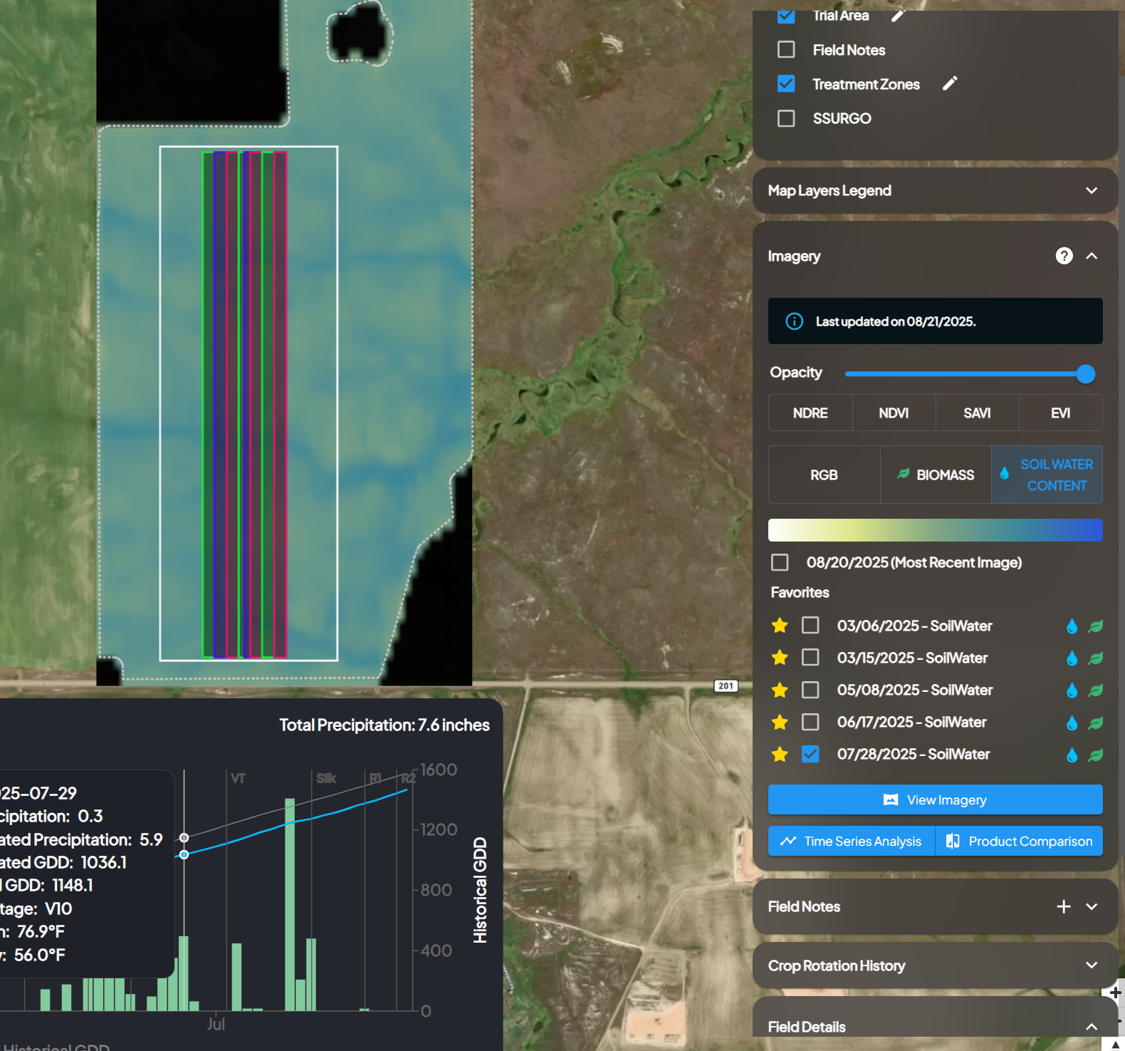
1. Satellite Imagery – Soil Water Content (SWC)
-
INVISION now supports Planet’s 20m resolution Soil Water Content index, giving users visibility into soil moisture levels across their fields.
-
How to enable: Super-admins can activate SWC via Imagery Admin → Order New Index.
-
Use Case: Soil moisture variability is critical for yield prediction, irrigation planning, and understanding water stress. SWC offers actionable insights beyond vegetation indices.
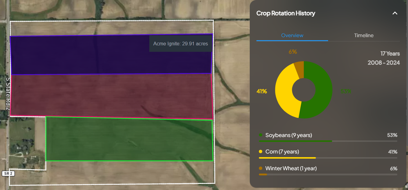
2. Crop Rotation History Panel

-
U.S. fields in View Fields now display 17 years of crop history (2008–2024) from the NASS Cropland Data Layer (CDL).
-
New fields: Any newly enrolled U.S. field will have crop history populated within ~1 hour.
-
Use Case: Provides immediate visibility into rotation patterns, residue carryover, and historical planting decisions — critical for agronomic analysis and sustainability programs.
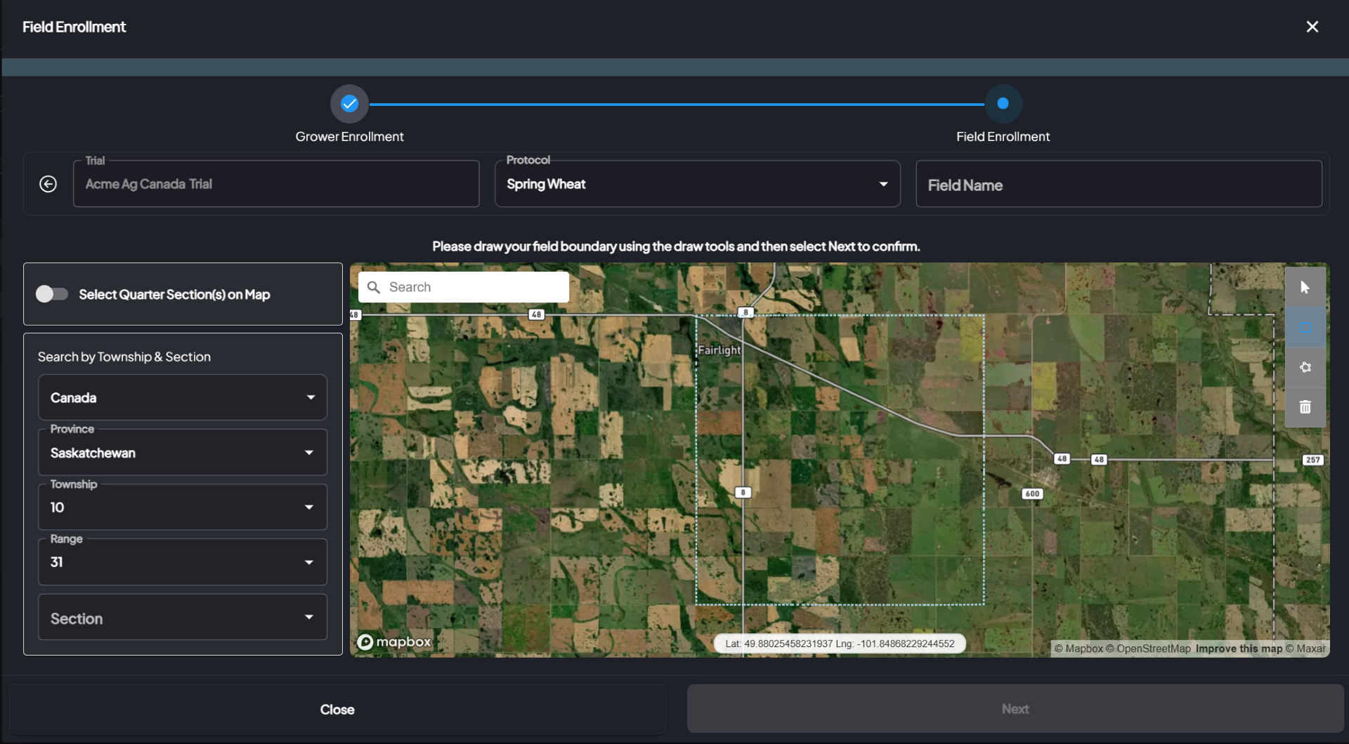
3. Canadian Township/Section/Range (TSR) in Field Enrollment
-
INVISION now supports the Dominion Land Survey (DLS) system for Canadian provinces (Alberta, Saskatchewan, Manitoba).
-
Users can create and enroll fields using Province → Township → Section → Quarter-Sections.
-
Use Case: Brings Canadian field enrollment workflows in line with existing U.S. TSR functionality, reducing setup friction for Canadian clients.
Enhancements
Project Management & Trial Setup
-
Automated Exports: Improved audit history (user, timestamp, status) and better error handling for machine data exports.
-
Document Studio: Email notifications now attach signed documents; signature workflow updated with clearer exit navigation.
-
Trial Operative Assignment: Assign multiple growers to a single operative in one action.
-
Trial Setup: Custom product setup now separates feature products vs competitor products during trial creation.
-
Field Admin:
-
Direct boundary edits now supported.
-
Added pre-defined CLU (Common Land Unit) overlays.
-
Sync reminders prompt admins to reset trial areas when boundaries are modified.
-
-
Terminology Update: All references to “SWAT Maps” renamed to EC Maps for consistency across platform.
GIS Workstation
-
“Take Me To” Link: Instantly jump to visualization of uploaded machine data. Example: Try it here
-
Assign Products Flow: Optimized with smaller payloads and normalized request formats, improving reliability.
-
Pin Tool: Pins now remain visible during selection and no longer trigger errors.
Insights & Dashboards
-
Yield Caching: Optimized by skipping finalized/archived trials, reducing compute load and improving performance.
-
Charts: Now display “Last Updated” timestamps for greater transparency.
-
Custom Dashboards:
-
Improved stability and reduced memory crashes.
-
Enhanced dataset management.
-
More flexible filters and chart controls.
-
Richer geospatial visualization options.
-
-
Soil Data Migration: All soil datasets (SSURGO, PLSS, land-units) migrated from the retired soils-service into Insights Service.
-
Benefits: Reduced infrastructure overhead, faster SSURGO/CanSIS access, and unified soil dataset management.
-
Enrollment & Field Management
-
Added grower/protocol metadata fields (enrolled by, field count).
-
Introduced Quick “Add Fields” actions for faster enrollment.
-
Boundary uploads now support .gjson files (alongside .geojson and .json).
View Fields (Trials Overview)
-
Field Notes: Completed notes can now have their location edited post-submission.
-
Productivity Map: Yield metrics now include color ranges for easier interpretation.
Bug Fixes
-
GIS Workstation: Fixed operation dates toggle and resolved pin display errors.
-
Trials Overview: Resolved access issues preventing operatives from viewing Project Progress.
-
Weather: Corrected duplicate precipitation values appearing in some U.S. fields in Season at a Glance.
-
Imagery Analysis: Fixed recalculation delays for large fields and updated exports to correctly filter excluded imagery stats.
Summary
INVISION v3.11.0 represents a major milestone in expanding agronomic insights and improving platform reliability. With Soil Water Content imagery, 17 years of crop history, Canadian TSR enrollment, dashboards, and full soil dataset migration, INVISION is now more powerful than ever for data-driven field management.
All updates are now live. For questions, feedback, or feature enablement, please reach out to the team.